

- Umang Sagar
- National Issue, Recent article
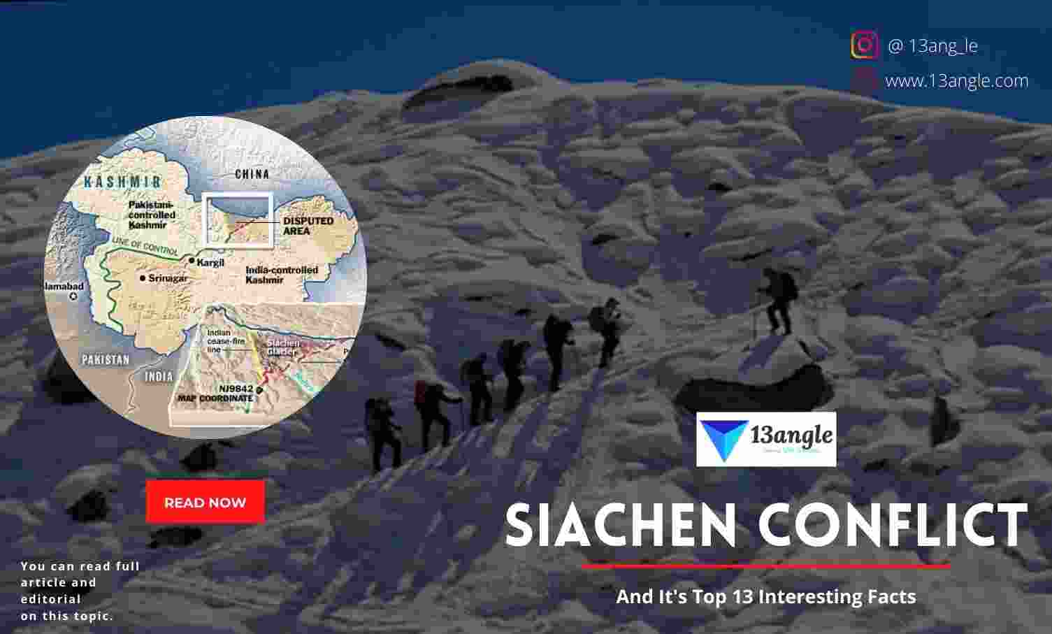
Siachen Conflict

Introduction
- After the British left the Indian subcontinent in August 1947, the two neighboring countries of India and Pakistan became independent states. Historically, the United States and China have had a history of hostility over the last six decades, and the two countries have gone to war three times. The Himalayan glacier of Siachen has become a major point of contention between the two countries, among other bilateral issues. It began as a military standoff in April 1984 but has since evolved into a major environmental issue affecting both sides of the border. Pakistani forces were stationed on the Siachen glacier’s Saltoro ridge’s southern slopes, while Indian forces were stationed on the ridge’s northern slopes. The 6300-meter-high glacier’s major passes, such as Sia La (6160 meters) and Bilafond (6300 meters), are also under Indian control (5550 meters). In 1984, the Indian forces had occupied the glacier before Pakistan had a chance to respond. With no end in sight to the conflict, the Siachen glacier is a strategic issue for both India and Pakistan. Although the Siachen glacier’s extreme weather is causing serious health problems for the troops stationed there (such as sunburn and acute depression, for example), this continues. Global warming and military activities have degraded the glacier, according to an article in India Today (2004). “The core of the glacier was melting”, the newspaper stated, citing reports from the International Union for Conservation of Nature (IUCN) and the International Union for the Advancement of Science (UIAA). Within 50 years, the glacier could be gone. Since the conflict began, glaciers in Pakistan and Afghanistan have shrunk by 30 percent (six miles) and toxic materials have leaked into the Indus River, which is used by both countries, according to Duparcq (2012).
- Rather than focusing on the costs of military conflict, he focused on the plight of the poor in both countries. It is to draw attention to climate change and call for immediate action on Siachen by citing reports from Green watch, the World Meteorological Index Organization, and the United Nations without which India is losing not just its strategically important war point but also a historical place of virtue and remembrance.
Causes
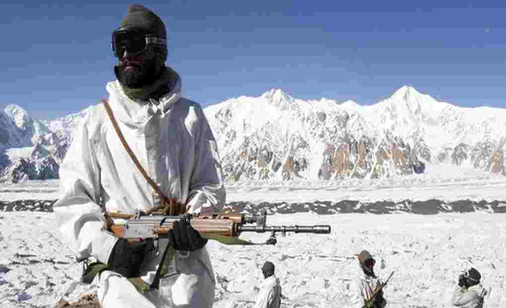
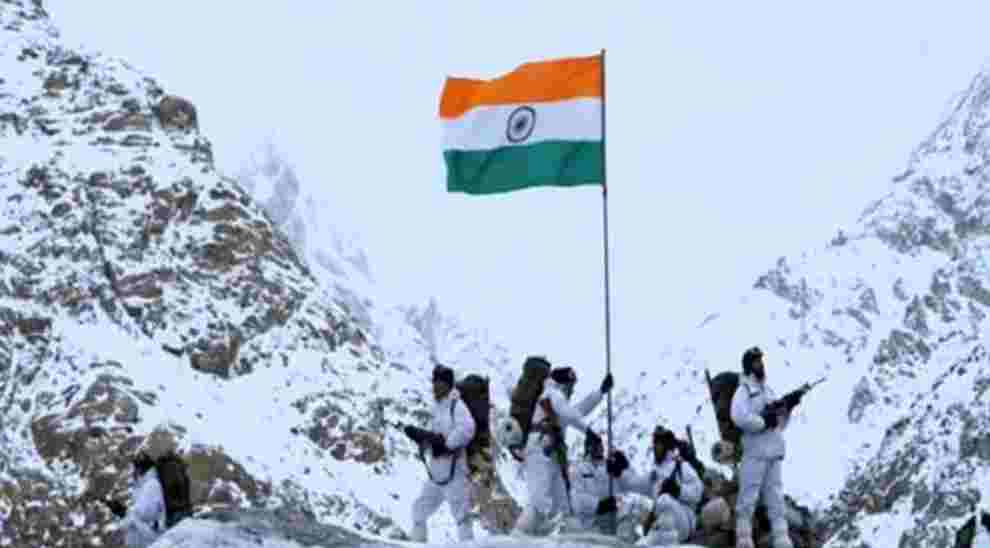
For more than three decades, India and Pakistan have been engaged in skirmishes on the Siachen Glacier, the highest point on Earth. Over 6,000 metres high, the militaries of both countries are permanently stationed in the region (20,000 ft). As a result of extreme weather and mountain warfare, more than 2000 people have perished in this hostile environment.
The Cease Fire Line (CFL) ended at NJ9842, but neither the 1949 Karachi Agreement nor the 1972 Simla Agreement specified who controlled the glacier. The UN assumed there would be no disagreement between India and Pakistan over such a frigid and desolate region. A demarcation line between India and Pakistan was established at the foot of the Siachen Glacier following a UN-mediated ceasefire in 1949. After this point, the Karachi Agreement stated that “thence north to the glaciers” applied to the largely inaccessible terrain beyond this point. An official “Line of Control” was established in 1972, extending from “Chhamb sector on international border [to] Turtok-Partapur sector in the north” following 1971’s Indo-Pakistani War and 1972’s Simla Agreement. According to the detailed description of its northern end, “the line of control runs north-eastwards to Thang (inclusive of India), then eastwards joining the glaciers” from Chimbatia in the Turtok sector. This ambiguous phrasing sowed the seeds for the ensuing bitter dispute.
A second addendum to the 1949 Karachi Agreement was drafted by the United Nations, and it shows the CFL as defined in paragraph ‘B’ 2 (d) of that agreement on a map of the state of Jammu and India, Pakistan, and the UN Military Observer Group all signed and ratified a Cease-Fire Line Agreement (CFL) in 1949, officially drawing the boundaries of the cease-fire zone. Information about Siachen and other glaciers was made public in 1956–58 by a scientific team led by the Geological Survey of India.

Pakistan began approving western expeditions to the east of mountain K2 after a boundary agreement in 1963 saw Pakistan cede the 5,180 km2 (2,000 sq mi) Shaksgam Valley to China.
Using the Bilafond La and Saltoro Kangri, Pakistan allowed a British expedition led by Eric Shipton to reach the Siachen glacier in 1957. [26] [Needs a page] Five years later, a joint Japanese-Pakistani expedition reached the summit of Saltoro Kangri with two Japanese and a Pakistani Army climber. As the game of politics began, these were some of the first moves.
Mountaineering expeditions applied to Pakistan in the 1970s and early 1980s because the US Defense Mapping Agency and most other maps and atlases depicted the Siachen area on the Pakistani side of the border. Several licenses were granted by Pakistan. Because these expeditions arrived on the glacier in possession of a permit issued by the Pakistani government, it strengthened Pakistan’s claim to the region. Both Teram Kangri I and Teram Kangri II were first conquered by a Japanese expedition in 1975, which entered Pakistan via the Bilafond La and reached the Himalayas via the Khumbu Icefall.
Formed by Jaroslav Poncar in 1978, the German Siachen-Kondus Expedition included members Volker Stallbohm, Wolfgang Kohl, and liaison officer major Asad Raza, and they crossed the Bilafond La to reach Siachen and set up camp on the Teram Shehr-Sichen junction. In 1979, WDR’s 3rd channel aired the documentary “Expedition to the longest glacier.”
There was no permanent presence of either India or Pakistan in the region prior to the year 1984. Colonel Narendra Kumar, then commanding officer of the Indian Army’s High Altitude Warfare School, mounted an Army expedition to the Siachen area as a counter-exercise after becoming aware of US military maps and the permit incidents. In a typical “or political” riposte, this 1978 expedition climbed Teram Kangri II and claimed it as a first ascent. As a rare occurrence for the Indian Army, this expedition’s news and photos were published in the widely read and widely distributed Illustrated Weekly of India magazine. “High Politics in the Karakoram” by Joydeep Sircar in Calcutta’s The Telegraph newspaper in 1982 was the first public acknowledgment of the Siachen conflict and maneuvers.
Major Combat Operations
- Pakistani generals in Rawalpindi were motivated to secure Siachen before India’s arrival by the discovery of repeated Indian military expeditions to the glacier. Operation Ababeel was the name given to this operation. According to a retired Pakistani army colonel, Pakistani planners made a tactical error in their haste to gather operational resources. An outfitter in London, which also supplied the Indians, is where the colonel says they purchased their arctic-weather gear. It wasn’t long before the Indians ordered 300 outfits, twice as many as we had, and rushed their troops to Siachen. The start of major combat operations on the glacier was marked by the acquisition of essential supplies required for operations in glaciated zones.
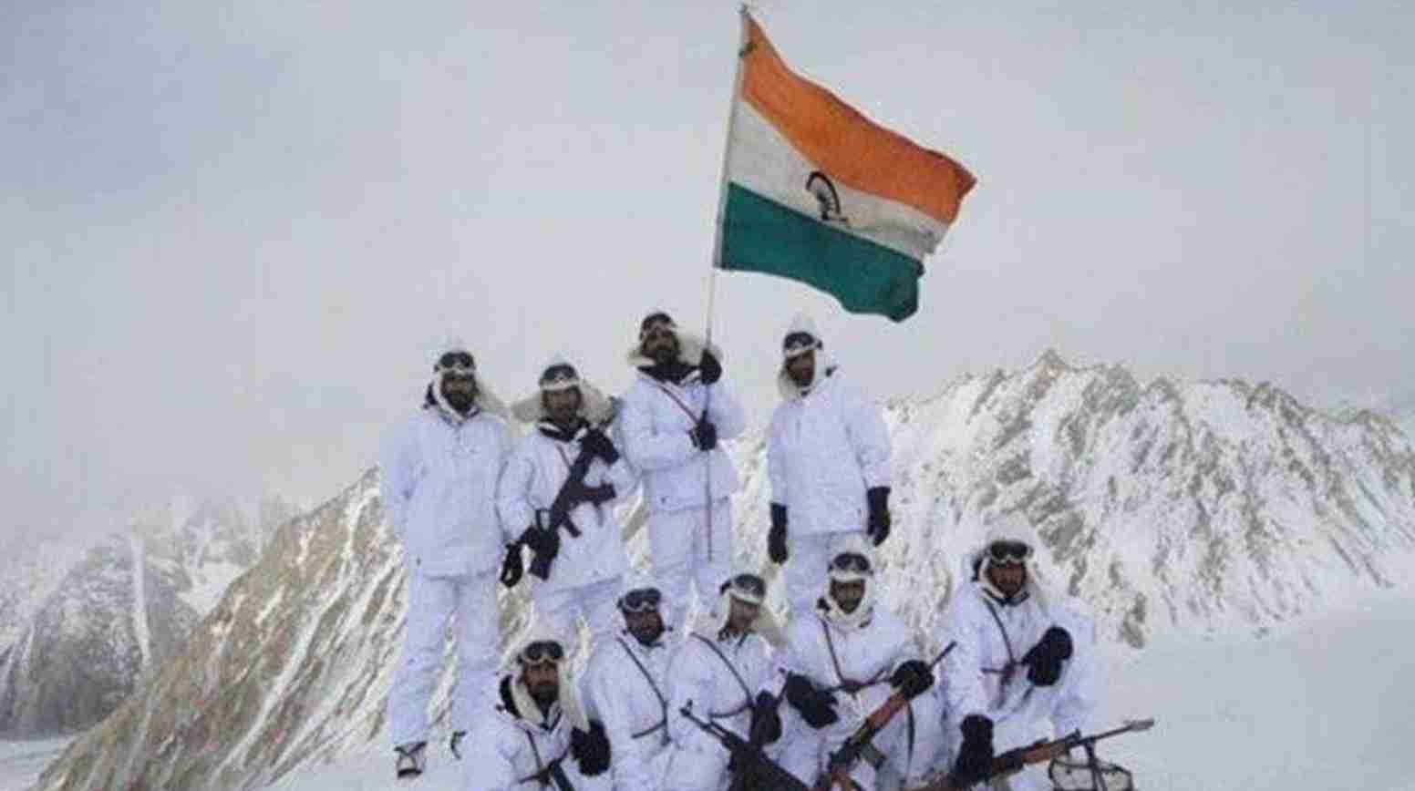
1. Operation Meghdoot, April 1984: The Indian Army, led by Lt. Gen. Manohar Lal Chibber, Maj. Gen. Shiv Sharma and Lt. Gen. P. N. Hoon learned of Pakistan Army’s plan to seize Sia La and Bilafond La on the glacier in this operation. As a precaution against Pakistani incursions, the Indian Army launched a counter-offensive. With the help of the Indian Air Force, the Ladakh Scouts and Kumaon Regiment take Bilafond La on April 13 and Sia La on April 17, 1984. During a helicopter recon mission, the Pakistani Army discovered the Ladakh Scouts’ presence on the passes. When the Pakistani Army learned of these new developments, it immediately launched an operation utilizing Special Services Group and Northern Light Infantry personnel to remove the approximately 300 Indian troops stationed in strategic passes. On April 25, 1984, a Pakistani-led operation erupted into a scuffle on the glacier, sparking the start of hostilities.
2. Operation Rajiv, which lasted from June to July 1987, saw the Pakistani army attempt to seize heights overlooking the key passes while Indian troops were stationed there. The seizure of a vantage point overlooking Bilafond La was one of Pakistan’s greatest achievements during this period. For three years, the Indian positions on the glacier were dominated by this feature known as the “Qaid Post.” An excellent vantage point was provided by the Pakistani Army’s Qaid post, which overlooks the Bilafond La area. Brig. Gen. Chandan Nugyal, Major Varinder Singh, Lieutenant Rajiv Pande, and Naib Subedar Bana Singh led an Indian Army assault on Pakistani forces at Qaid Post on June 25, 1987.[34] Subedar Bana Singh received India’s highest gallantry award, the Param Vir Chakra, for his part in the assault. Dedicated to Bana, the post was renamed Bana Post.
3. Qaid peak was retaken in September 1987 by the Pakistan Army in Operation Vajra Shakti/Operation Qaidat, which was led by Brigadier General Pervez Musharraf (later President of Pakistan). At the newly constructed Khaplu garrison, Pakistan Army SSG units (1st and 3rd battalions) gathered a large task force for this purpose. Operation Vajrashakti was launched by the Indian Army in anticipation of Operation Qaidat to protect the newly renamed Bana Post from Pakistani attack.
4. When the Indian Army attempted to seize a Pakistani post overlooking the Chumik Glacier during Operation Ibex in March 1989, it was repelled by Pakistani forces. Pakistani troops remained in their positions despite the operation’s best efforts. The Pakistani logistical hub in Chumik, Kauser Base, was attacked by Indian artillery under Brig. R. K. Nanavatty and destroyed. After Operation Ibex’s destruction of Kauser Base, Pakistani troops were forced to leave their Chumik posts.

5. When a large Pakistani assault team attacked the Bahadur post in Chulung, the Indian Army launched Operation Trishul Shakti to defend it. A Pakistani helicopter was shot down by an Indian Igla missile on August 1, 1992, killing Brig. Masood Navid Anwari (PA 10117) and several other soldiers. As a result, the Pakistani assault lost steam and came to a halt.
6. May 1995: Pakistan Army NLI units attacked Tyakshi post at the southernmost end of the Saltoro defence line in a battle known as the Battle of Tyakshi Post. Troops from India were able to repel the attack. Pt 5770 (Naveed Top/Bilal Top) in the southern edge of the Saltoro defence line was taken by Indian troops in June 1999, under Brigadier CC Katoch and Col Konsam Himalaya Singh.
Environmental Concerns

The Pakistani control of Siachen gives them the ability to install radar and monitor all Indian airforce activity in Ladakh, so India maintains its presence despite the high cost of this. If there were a conflict, it would unite the Chinese-Pakistani front so that they could strike at India together. There is no need for expensive defence infrastructure in the Nubra Valley, which is a huge saving for Indian forces. When it comes to Pakistan, Siachen is a big question mark because it doesn’t allow India to launch an offensive on Pakistan, but it raises the possibility that Pakistan may not be able to defend its territory. As a result of the Kargil War of 1999, supplies to Ladakh and Siachen were obstructed.
Because of environmental and financial concerns, both sides have expressed an interest in moving away from the glacier. Many talks have taken place, but no significant progress has been made. The process was further complicated in 1999 when Pakistan violated the ceasefire line and built bunkers on the Indian side and began artillery fire on Indian strategic highways, resulting in the Kargil War. There will be an extremely difficult and expensive time for India to return to the glacier even if Pakistan and the Indian government agree to demilitarise the area. Since the 2020 Galwan Incident, in which the border understanding was violated, China’s steady advance in the Himalayas has also been a source of concern because of the possibility that a similar incident could occur, causing significant damage to India. The Pakistani military considers its defeat at Siachen to be a major setback.
The Siachen Glacier is considered Pakistani territory by Pakistani generals, who believe that India has stolen their land. Benazir Bhutto publicly slammed Pakistan’s military as “fit only to fight its own citizens” when India seized the Saltoro Ridge in April 1984. India captured “Quaid Post” and renamed it “Bana Top,” after Naib Subedar Bana Singh, in June 1987, and Bhutto once again taunted Pakistani generals by telling them to wear bangles because they couldn’t fight on the Siachen.
Kargil War, Cease Fire and Way Ahead

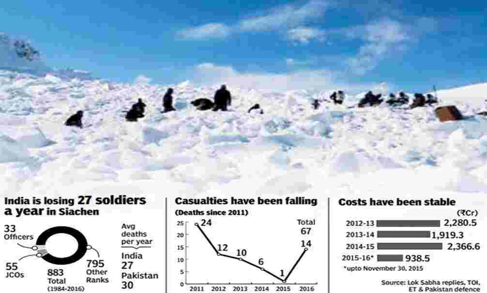
In 2003, a truce was signed. In the years prior to that, severe weather conditions claimed the lives of more soldiers each year than incoming enemy fire did. Frostbite, avalanches, and other complications were to blame for an estimated 2,000 deaths on both sides by 2003. Each country has about 3,000 soldiers stationed at one of the 150 outposts along the glacier. The cost of maintaining these outposts in India and Pakistan is estimated at a total of $300 million and $200 million, respectively. The helipad at Point Sonam, at a height of 21,000 feet (6,400 meters), was built by India to serve as a resupply point for its armed forces. With the difficulty of reinforcing or evacuating the high-altitude ridgeline, India developed the Dhruv Mk III helicopter, powered by the Shakti engine, which was used to lift and land personnel and supplies from the Sonam post in Pakistan, the world’s highest permanently manned post. A phone booth has also been installed on a glacier in India. The Kargil War of 1999 was triggered by Pakistan’s belief that India would be forced to withdraw from Siachen in exchange for a Pakistani withdrawal from Kargil, which was one of the key factors in the conflict. In light of Pakistani incursions into Kashmir following the Kargil War, India decided to keep its military outposts on the Siachen Glacier in place.
The glacier and its surroundings have been harmed by decades of military operations. There are two rivers that flow into the upper Indus from Siachen: the Nubra and Shyok, which are important water sources for both India and Pakistan. A daily average of 2,000 pounds of human waste and heavy artillery containing toxic metals like lead are dumped into the glacier’s crevasses. Water pollution for downstream human communities and impacts on the landscape for vulnerable species like the endangered snow leopard and Himalayan ibex have been serious consequences of this waste.
Glacial warfare has both positive and negative effects. Siachen Glacier’s conditions have deteriorated as a result of the damage inflicted by Indian and Pakistani forces on the glacier. Seasonal snowfall is the primary source of mass for most glaciers that have served as battlefield backdrops throughout history. While glaciers in the Karakoram Himalayas gain mass primarily from unexpected avalanches, Siachen is located there. Indian and Pakistani troops face a potentially lethal challenge in this harsh environment year-round.
At Siachen, there is always something new to fear. For weeks on end, Indian and Pakistani soldiers must brave temperatures as low as -40°C (-40°F) and deadly avalanches that have been known to wipe out entire outposts even when no one else is around to threaten them. An avalanche in Pakistan in 2012 killed 129 soldiers and 11 civilians, destroying the entire battalion’s headquarters.

Since the harsh glacial terrain has dictated the state of warfare on the Siachen Glacier, both Indian and Pakistani forces have been forced to reevaluate their strategies and tactics. According to Smith’s study, “It is the greatest factor in the psychology of combat,” “The first and last consideration for any mission logistics, and the chief determinant of what supplies are available and when creating an unusually challenging operational environment unlike any other.” Inability to obtain supplies in Siachen limits operations and puts troops in harm’s way. Inaccessible to even the most durable vehicles, Siachen is relying solely on airlift deliveries and pedestrian paths to get supplies to its remote outposts. In the event of a snowstorm, air delivery of supplies may be impossible due to avalanches cutting off troops from their usual routes. In addition, many of India’s heavier helicopters cannot fly as high as Siachen Glacier because of their weight and altitude. In the event of an emergency landing, pilots must avoid numerous deep crevasses on the glacier’s surface in order to avoid a sudden strong wind that could necessitate an emergency landing.
Siachen Glacier’s outposts experience frequent periods of strict rationing as a result of their frequent isolation as a result of these adverse conditions. A storm or a crevasse can easily trap a group of soldiers if they don’t tie themselves together before venturing outside. Despite the fact that he was “tied to a rope anchored inside the tent” in 1992, Indian troops found the body of one soldier weeks later.
Indian and Pakistani forces rely on specialized training that includes ice climbing techniques and avalanche safety to survive in these circumstances. The extreme climate at the outpost necessitates the use of specialized equipment, such as gun emplacements and anchor-building tools. Additional supplies and training necessitate a much longer and more expensive deployment to Siachen, according to the study. Between $200 million and $300 million is thought to be the average annual cost of Pakistani operations in Siachen.
- Pakistan and India’s military presence on the Siachen Glacier has become increasingly costly in terms of economic, environmental, and human costs. Studying the consequences of turning a glacier into an international conflict zone is useful for those of us who live far away from the site of the conflict.
Conclusion
Sachen is now a forgotten war. At some point when the composite dialogue is re- summed, another round of talks will be scheduled. Very little is likely to emerge unless a political directive is issued to conclude the talks. This is difficult for any incumbent government since the opposition will make political capital of any move to give up territory. It is high time that civil society on both sides debates the issue and brings pressure on their respective governments to do their duty by negotiating an honorable withdrawal from an area that should not have been occupied in the first place. Considering the fact that a clock of destruction has been ticking for 25 years, there is a need for some urgency to be injected into the process. India and Pakistan can ill-afford the additional expenditure of maintaining thousands of troops at extreme altitudes. A million dollars a day could go some distance in the fight against poverty and hunger.
In the meantime, there is an alternative. General Inder Gill had recommended a unilateral withdrawal back in 1997. India could pull out from the posts on Saltoro while suggesting to Pakistan to do the same. In other words, disengage troops on both sides to lower altitudes without any preconditions. This is an unlikely scenario due to the prevailing situation. Here is a quote from a letter written by a retired air force officer, Group Captain A G Bewoor to the Indian Express on 8 May 2003 “Siachen is not worth another dead soldier, it never was. Siachen and only Sachen have the ability to get sorted out without any impediment and without being linked to the other part of J&K.”
Top 13 Interesting Facts About Siachen Conflict
Siachen is the world’s costliest battlefield.
Siachen is the 5th largest glacier in the Karakoram Range and second-largest glacier in the world.
The Siachen glacier, which covers an area of 76 km2, has harsh conditions due to the glacier’s constant threat of avalanches, crevasses, and high winds, as well as a variety of other potentially lethal altitude-related ailments.
Central Asia and the Indian subcontinent are separated by the Siachen glacier, which is located in Pakistan.
The Saltoro Ridge of the Siachin glacier serves as a divider that prevents the direct linking of PoK with China, stopping them to develop geographical military linkages in the area.
If Pakistan gets the location advantage in Siachen, it would become a big threat to India from the west in Ladakh in addition to Chinese threats from Aksai Chin of the east.
Due to its control over Saltoro Ride, India is better placed to strike a bargain while settling bilateral territorial disputes with Pakistan in the future.
The temperature in Siachen glacier in winters drops to below -60 degrees. There are also constant threats of avalanches, crevasses on the glacier, and high-speed winds. Soldiers stationed in the area are affected by a range of fatal altitude-related ailments like frostbites, hypoxia, hypothermia and whiteouts.
For India, costs of maintenance in the region are about Rs 5 crore a day. India has spent over Rs 7,500 crore on the procurement of clothing and mountaineering equipment for soldiers.
In one of the worst-known incidents, 140 Pakistani soldiers were killed after an avalanche slammed into their army camp in the Gyari region of Siachen in 2012.
In April 1984, India urgently dispatched troops to Siachen under secret Operation Meghadoot. Indian troops reached the glacier a week earlier than Pakistan. By the time Pakistan soldiers reached the region, India had already got control of the glacier and the adjacent Saltoro ridge, using Col Kumar’s maps.
In the Siachen Glacier; the soldiers need to have food of more than 4000-5000 calories per day but they don’t get it. Inadequate food availability reduces the weight of the soldiers between 5 to 10 kg in 3 to 4 months. The special food of these soldiers is prepared by the scientists of the Defense Research and Development Organization (DRDO).
Currently, India has the dominating position on the Saltoro ridge, under its control. The Pakistani posts are located 3,000 feet below that place.
