


- Umang Sagar
- Place, Recent article
The Siliguri Corridor: India’s Chicken’s Neck

Introduction
- Located in west Bengal, 60-kilometer-long and 20 kilometers wide, the Siliguri corridor connects North-Eastern states to the Indian mainland. The partition of India let the formation of Bangladesh during 1947-48. Siliguri corridor is not only an important trade route but essential as a gateway to South-East Asia for India. The region is surrounded by multiple countries like Nepal, Bhutan, Bangladesh, and China, adding to its inflating significance. China’s strategic interests and recent developments have forced the Indian government to focus on the narrow strip. Let us understand the basic geography, terrain, and geostrategic significance. We’ll also try to understand how china’s involvement and investments in neighboring countries have put the strategic location in menace. We will learn about the role played by Bangladesh in securing the corridor and the steps India took.
Terrain
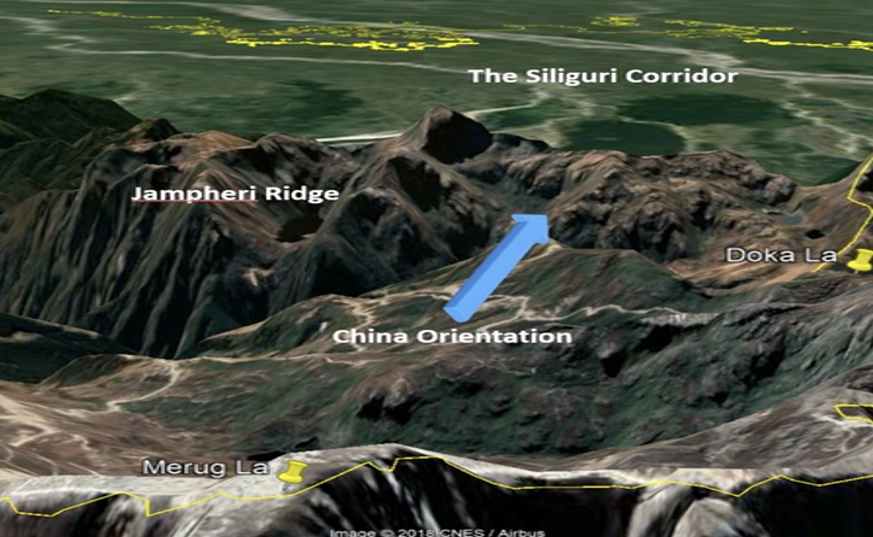
Siliguri Corridor (Chicken’s neck) is a narrow stretch of land which is in the Indian state of West Bengal. The British built the corridor to use it as a trade route. Mainland India related to North-Eastern frontier agencies through the thin line. This specific line involves Siliguri corridor/Chicken’s neck. The corridor is 60 km long and 20 km wide. While the eastern part is wider, the narrowest point of the western part between these two countries is only 17 km long. In the north of this location Sikkim, China and Bhutan are located while Nepal is in the West, Bangladesh in the South and Assam in the East. Chumbi Valley in Tibet is located at 130 kilometers from Siliguri Corridor. At the tip of the Chumbi Valley, the Tri-junction of India, China, and Bhutan (Doka La region) is located which has now become a standoff point.
The Siliguri Corridor extends from Jalpaiguri in Darjeeling to the Tarai areas in West Bengal. Himalayan mountains have located at the North of this corridor. Mount Kanchenjunga of the Himalayas is situated on the India-Nepal border. These mountains are sources of two major rivers, the Teesta and Jaldhaka rivers. Teesta river rises in the Pauhunri mountain of the eastern Himalayas, flows through the Indian states of Sikkim, West Bengal, and Bangladesh and enters the Bay of Bengal. It merges with the Brahmaputra river at Phulchhari Upazila in Bangladesh. Teesta is the largest river of Sikkim and the second largest river of West Bengal after the Ganges. The Jaldhaka river is a tributary of the Brahmaputra flowing through India, Bhutan and Bangladesh. River Jaldhaka, along with River Teesta has created major flooding multiple times in Bangladesh during the monsoon season between June to September. Teesta and Jaldhaka River passes through the corridor and merges with River Brahmaputra in Bangladesh. The corridor is in the Tarai region of West Bengal. Due to the presence of sandy soil, it is difficult to construct Railways and Roadways in the region. Sandy soil is loose in texture. North-east witnesses record rainfall which makes it difficult to construct development projects. The area has a population of 50 million and the ethnicity of Nepali and Bengali immigrants is major. Being in proximity to Bangladesh, demographical change by illegal immigrants is an important factor of focus.
Importance Of Chicken’s Neck
- The Siliguri corridor is an important trade route between Northeastern states and the mainland. The corridor also hosts the only railway freight line between the Indian mainland and her Northeastern part through Siliguri. Darjeeling tea and Timber are major economic factors. Strategically, the Siliguri corridor helps connect military stations near LAC (Line of Actual Control) through railways and roadways. NH-31 is a strategic highway that connects Siliguri to Guwahati in Assam. NH-10 connects Siliguri to Gangtok in Sikkim where Army corps 33 is located. Army Corps 33 participated in the Sino-Indian war of 1962 and captured some Chinese communication equipment. This equipment is kept in the corps of Signals museum in Jabalpur. New Jalpaiguri Railway station (NJRS) which is located near Bangladesh Border relates to Guwahati through a railway line. Guwahati from here is connected to Tawang in Arunachal Pradesh which is 25 kilometers away from the LAC. The Army core corps is located at Tawang. The Road line of NJRS is connected to Army 3 corps HQ in Dimapur, Nagaland and Dibrugarh in Assam. To this degree, the corridor plays an important role in providing supplies to the military formations in the North East. The Siliguri corridor also helps India to boost the “Act East Policy” by facilitating connectivity between the Indian Mainland, her northeastern states and further ASEAN countries in Southeast Asia.

- India’s Act East Policy cornerstones the prolonged neighborhood in the Asia-Pacific Region. The Policy was conceived as an economic initiative in the beginning. Now it has gained strategic, political, and cultural proportions involving the establishment of institutional mechanisms for dialogue and cooperation. The Association of Southeast Asian Nations (ASEAN) is a union of 10 member states in Southeast Asia, which promotes intergovernmental cooperation and smoothens economic, political, military, educational and sociocultural unification between its countries and countries in the Asia-pacific region.

- The corridor is bordered by multiple countries. Bangladesh is bordered by Malda, North Dinajpur, South Dinajpur, Cooch Behar and Jalpaiguri. Darjeeling and Alipurduar border Nepal and Bhutan. The Siliguri corridor as an important international border trade route can help build better trade relations with ASEAN countries. The corridor proves significant in countering illegal immigration, cross-border terrorism and Islamic Radicalization which might cause insurgency in the northeastern states of India. Southeast Asia being notorious for a golden triangle, is prevalent in organized crime and drug trafficking between Myanmar, Thailand and Laos. This region is bordered by the Indian states of Arunachal Pradesh, Nagaland, Manipur, Mizoram, and Tripura. This is a critical area as most of the drug trafficking is done through northeastern states which is a major internal security threat for India. Securing the corridor can prove to counter the issue of drug trafficking. The corridor is also located near China’s Tibet region, a geographical advantage which India can use to keep an eye on China. China has constructed many roads and Air strips in this region. In such a manner, the Siliguri corridor can prove to be an advantageous strategic location.
Measures Were Taken By India
India has constructed two strategic air bases, Bagdogra and Hasimara on this crucial corridor. These bases provide additional security to the eastern and western portions of the corridor. In 2019, the Border Road Organisation (BRO) constructed a motor-able road connecting the Bheem base with the Doka La region. Construction of the redline has reduced the travel time from 7 hours to 40 minutes. The BRO has also built a Double Lane Classic 70 Modular Bridge in 2021. This has strengthened the connectivity in the Doka La region.
The development of the northeastern states is vital for the corridor. Several projects like connectivity, hydropower, skill development, sustainable development etc. have been launched for the development of the northeastern states under the Japan-India Act East forum in 2017. As part of India’s “Act East Policy”, this forum seeks to encourage collaboration between India and Japan in the North Eastern region. India is pursuing and advancing its Act East Policy through the India-Japan Act East Forum, while Japan is advancing its vision for a “Free and Open Indo-Pacific.”
Apart from this, India has taken additional steps to develop connectivity with neighboring countries. India has been constructing a trilateral highway connecting Manipur to Thailand via Myanmar. Eventually, it would connect Mae Sot, Laos, and Cambodia which would boost the economy. Under the multi-modal Transport project, India has also been trying to connect the Sittwe port of Myanmar with Kolkata Port and Mizoram (Kaladan project, 540 Kms). This step led to an optional route for connectivity in the northeast. Bangladesh played an important role in securing the corridor. In 2020, both countries have signed a bilateral agreement to sail goods to Agartala via Chittagong port in Bangladesh. Before 2020, difficult terrain in the Northeast of the corridor was used to transfer the goods.
India has several forces deployed on its borders. The Indian Army and Indo-Tibetan Border Police (ITBP) guard the border with china. Sashastra Seema Bal (SSB) is deployed along the border with Nepal and Bhutan and Border Security Force (BSF) for Bangladesh. The area is also patrolled by Assam Rifles and state police forces including the West Bengal police.
Build-Up By China
As India is trying to peacefully develop this region, China has destabilized it by creating chaos through recent developments. Following are some of the developments made by china.
DOKLAM: Doklam Plateau is the area where the borders of India, China, and Bhutan meet. According to Bhutan, there’s a tri-junction point located at the Doka La pass. It is guarded by the Indian Army as Doka La pass is in the Sikkim sector. China never accepted this assertion. In 2017, China started building roads in this region of contention to connect the Chinese territory of Donglang with Doklam. This linkage would let china easily mobilize its troops and ammunition on the border. China is trying to shift the tri-junction point from Doka La to Gamocha which would let them operate easily.
- ARUNACHAL PRADESH: By utilizing a mimeograph of maps, china has claimed its territory in Arunachal Pradesh. To strengthen these claims china has used intimidating tactics. China built the Zangmu Dam on the Brahmaputra river in 2015. The river is considered the lifeline of the northeast region. Brahmaputra river originates from Tibet and enters the northeast region. The Zangmu Dam will not only impact the northeast but the lower riparian state of Bangladesh as well.
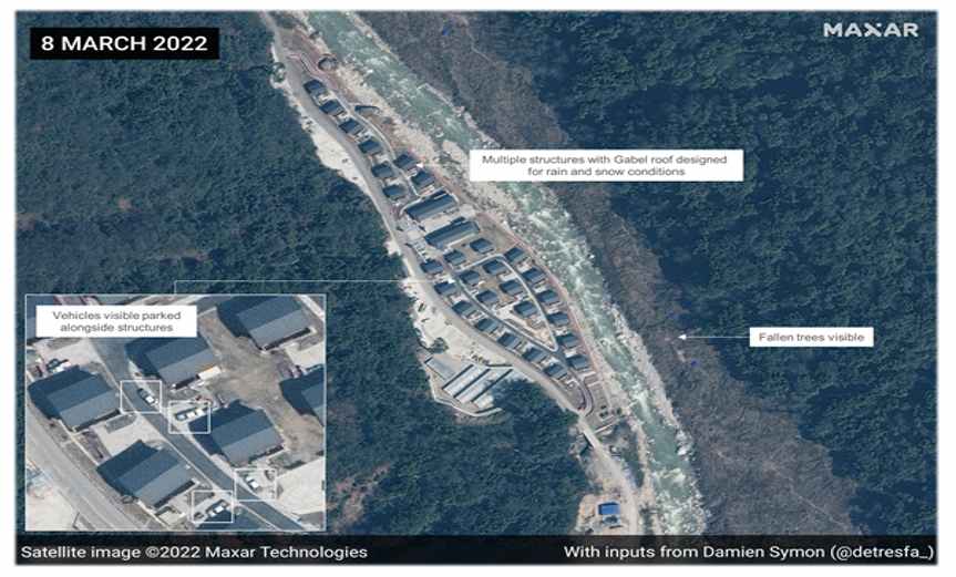
- China’s Western Theatre Command is located at Chengdu which is close to Arunachal Pradesh. Recently, Lhasa in Tibet was connected to Nyingchi through a railway line (the Lalin Line). Nyingchi is in the upper Siang district of Arunachal Pradesh, only at 40 kilometers. The railway line is further connected to Chengdu station which would destabilise the border region. In 2021, satellite images revealed that china has built a village of 101 houses in the upper Subansiri district which is an Indian territory.
Neighbouring Countries
With respect to Belt and Route initiative, china has started developing infrastructure in neighboring countries.
1. NEPAL: In 2018, the Trans-Himalayan multi-dimensional connectivity network was announced China and Nepal. This economic corridor initiated several projects. For example, the China-Nepal railway line would connect Katmandu and Shigatse. Apart from this, Three North-south corridors are being established to develop transport infrastructure. These corridors are Karnal, Gandaki, and Koshi economic corridors.
2. MYANMAR: In Myanmar, China has developed Kyaukpyu port and a naval facility at Coco island near the Indian territory of Andaman and Nicobar island. With these steps, china is trying to assert its hegemony in the Bay of Bengal. China by establishing a cordial relationship with Myanmar Army has threatened the northeast border of India. The Rakhine state of Myanmar is rich in oil and Natural gas. By connecting the Rakhine state with the yuan through the pipeline, china has reduced its dependence on the middle east.
3 BANGLADESH: Eventually, china has tried to bring Bangladesh into its strategic sphere. To improve economic relationships, China, on July 1st, 2020, made 97% of Bangladesh products duty-free. China has offered $1 Billion to spend for the restoration of the Teesta river. With the Kunming-Chittagong road link, China is resolving road connectivity issues. China has created an anti-ship missile launch pad at Chittagong port. In 2016, China invested between $11- $15 Billion and developed Payra Deep Sea Port. With this economic and political manoeuvre, china has threatened India’s Chicken neck. These steps taken by China can prove to become a major factor of deep influence in the northeast.
4. CHINA: China with CPEC (china Pakistan economic corridor) in the POK (Pakistan occupied Kashmir) and infrastructure projects in LAC, trying to threaten India from the Western and Eastern front. Economically, by capturing this corridor, China is trying to reduce its dependence on sensitive choke points like the Strait of Malacca. China is asserting domination in Southeast Asia. Hence, the strategic influence of Bangladesh has increased. By connecting the Siliguri Corridor to Chittagong, china can project its dominance in the region of the Bay of Bengal. The corridor is located in the North, and the significance of Bangladesh has increased.
The strategic location of Bangladesh is an advantage for china. Bangladesh shares three fourth border with India which gives china an advantage to monitor Siliguri Corridor. Kolkata-Agartala linkage via Chittagong port can be a viable trade route to swiftly reach in the northeast region.
Options For India
- The above analysis puts the spotlight on how important the Siliguri corridor is in India’s geo-strategic sphere. Following China’s Involvement as a hegemonic posture, this vital link proves to be more significant. India can ensure connectivity in the northeast region and focus on development simultaneously. India can handle Chinese deterrence in the Doka La region by strengthening connectivity. India can build a strong Stand in southeast Asia by developing relations with multilateral organizations like BIMSTEC, QUAD and ASEAN. India should develop a sustainable long-term border solution with china. With no border rigidity, India will then be able to counter internal threats.
Top 13 Interesting Facts About The Siliguri Corridor
The corridor was used as a trade route by the British.
There is no free trade agreement between India and Bangladesh.
The Tetulia Corridor is an alternative to the Siliguri Corridor.
The Tetulia corridor is proposed under article VIII of the India-Bangladesh trade agreement, 1980. It states that “the two governments agree to make mutually beneficial agreements for the use of their waterways, railways, and roadways for trade between the two countries and for passage of goods between two places in one country through the territory of the other.” The proposal is still in the initial stage.
Militant groups known to have used the corridor include the United Liberation Front of Asom (ULFA) and the National Socialist Council of Nagaland (NSCN).
The security threat to this corridor was heightened during the 2017 Doklam incident (India-China border standoff).
There’s a novel called Dragon fire by Humphrey Hawksley which briefly projects a situation where China cuts off India’s land route to its northeastern territories.
Another novel called Assassin’s Mace by Brigadier Bob Butalia also involves a situation involving Doklam and Jaldhaka River.
The corridor is formed by the Mechi River in the east.
The corridor is bordered by Bangladesh, Nepal, Bhutan, and China.
The local tribe here is known as Lepcha Tribe.
The introduction of the famous toy train changed Siliguri forever.
Siliguri is now the fastest-growing city in Eastern India after Guwahati.